Object


Organisation


History


Application


News & Views


REPORT ON A VISIT TO THE AIR MOUNTAINS AND TENERE DESERT

FEBRUARY 2004


BY DAVID LYON


PURPOSES.

1.      To  find and photograph the site of H Barth’s camp at Tintellous  as identified and photographed by FR Rodd in 1920,
and other sites at Assara and Aouderas.

2.      To Photograph Barths House in Agadez

3.      To see Rock reliefs and pictures at Dabous and Iwellen

4.      To visit the fossil lake at Ti-n-Ouaffadene 

5.      To visit the Blue [marble] mountains in the Ténéré desert

6.      To commission from traditional craftsmen and hear traditional poetry, singing and dancing.


Organisation and Travel.


The 16 day trip was arranged  by Agadez  Expeditions, run by Akly and Celine Joulia.


Travel from London was via Paris to Niamey, where a day was spent visiting the National museum, a good introduction,
and the good quality craft markets therein, followed by an afternoon in a pirogue on the Niger.


Day three was an 11 hours drive [950km] to Agadez.  Repeated in reverse at the end of the trip. With the opening up of
cheaper charter flights from Paris to Agadez it will be easier on the body and the purse to go direct.  The cost of one
vehicle from Niamey to Agadez is Euros 1200.


Travel from Agadez, for 5 people, accompanied by both Joulias, two drivers, a cook and a general assistant was in two
Toyota Land Cruisers and a Toyota pickup. Total distance covered was approximately 1300 km, Of this 200 was on
asphalt and the rest on dirt roads or off piste.  The standard of driving was excellent. One vehicle stuck once trying a 
steep dune. Sand channels were never needed


Akly Joulia is of Tuareg and French parentage and Celine is French. Both speak English, French, Tamashek, and
Hausa. They were key to the party of a Ione man and four women getting to meet people and visit schools and surgeries.
Their contacts were essential to arranging Tende [dances] and a recital by a traditional poet and singer in the Ténéré.

The Joulias have a deep knowledge of the history and geology of the area.  They are committed to the support of the
 traditional lifestyles of the Air Tuareg through the development of tourism.


Accommodation was in the Joulias’ hotel in Agadez, a pension in Iferouane and in tents. Food and drink were imaginative
within the resources available. There was bottled drinking water throughout, together with wine or beer. Hot washing water
was available in small quantities night and morning. There was a camp- fire each night.


Temperature varied from 35c down to 5c.  There was rather more wind and blown sand, together with haze, than expected.  Conditions overall were comfortable.  Dawn was 0600 and dusk 1800.

Each days journey stared about 0815 and finished by 1700 to give time for the crew to set up camp and the party to
explore the area.


The best gifts to take are necklaces, packs of needles and nail varnish for the women and aftershave and small files
 [£1 for 5 small ones in any good car boot market] for men.


There are a wide variety of places to visit in the Air and Ténéré. Travel can be by vehicle or on foot with camels, or on camel,
both with vehicle back up.  Time and cost and specific interests will determine any party’s specific trip.  It is only 5 years
since the end of the rebellion in the Air and Ténéré region and  the Joulias are keen to develop new routes, particularly into
the remoter areas of the region.


By far the most significant cost element is transport. The conditions are very hard on vehicles. To have vehicles in good
condition undoubtedly enhances the enjoyment of a 12 day  trip.


The 11 day  route  from Agadez went north to Iferouane and then to Temet, at the base of Mt Greboun before turning east
to the fossil lake at Ti-n-Ouaffedene, south to the Blue Mts, Adrar Chiriet and  then back to Agadez via Timia and Aouderas.


DAY- BY- DAY DESCRIPTION


Day 1: Agadez to camp site 2hrs east of Iferouane.


200km drive on asphalt on the road towards Arlit before turning east on a rough road to Gougaram starting at 0930.  En
route visit to the Rock drawings at Dabous, including the outstanding low relief giraffes, some 18feet high. This was the
only site visited with any guardian. There is a small grass hut where Tuareg tea is provided and is a good place for lunch.

From Gougaram the track passes through a mixture of granite outcrops and volcanic fields with thorn trees and grass in
shallow gullies.  Camp was made off the track under a large granite outcrop that gave some protection from the wind
about 2hrs drive west of Iferouane. An 0800 start from Agadez would enable arrival at Iferouane the same evening.


Day 2  : Iferouane.


 Arrival mid morning.  Accommodation at the Pension Tellit.  Good sized double rooms with ensuite bathrooms with cold
 running water, shower and lavatory.  Good food.  Exploring the gardens we were given a guided tour by its owner. Barley,
Onions, Cabbages, Tomatoes, lettuce were growing. Irrigation system throughout by trench fed from well with a petrol
driven pump.  Visited the small museum and the medical center. The latter is very basic. Healthcare is provided by the
army, who have a post at Iferouane. On return home we gave two lectures which raised money towards medical equipment
 which we sent out.  There is a cooperative silversmiths shop with some dozen members. Little hassle when viewing and
 leather bags on sale as well as jewellery. You need to be able to recognize the difference between sterling [92.5%] silver
 and nickel alloys of lower silver content, or plain nickel.  Silver is whiter, and can be bent in your fingers. If in doubt take
pieces into the sunlight where the difference is easier to spot than inside.  The prices paid for Silver earrings varied from
about CAF 8,000 to CAF 13,000 and crosses  and necklaces from about CAF 10,000 to CAF 25,000 depending on the
size and the design. There is quite a variety in the quality of the detailed working and it is worth taking time to get a good
feel for this.  Initial asking prices were way above final prices in most cases, some times by several hundred per cent.
Nickel prices are much lower.  Celine Joulia was most helpful in advising how much to pay.  Knowing we would have the
opportunity to buy at several places on the trip, some way out in the middle of nowhere, we spread our purchasing.
This helps the Joulias to encourage those smiths in the more remote places to maintain quality and experiment with new
 designs.
 

In the evening there was a village dance. It does not take much for the tuareg to dance, but the principle opportunity on this
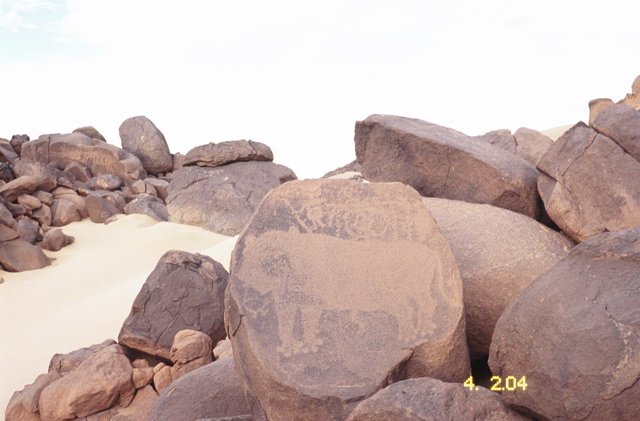
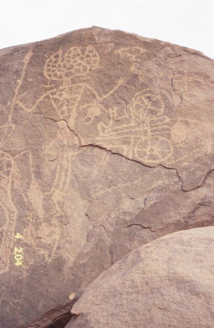
occasion was the presence of our resident guitarist, assalay, somewhat of a local popstar.  People form three sides of a
rectangle with one end left open. The women provide the music, chanting, ululations and drums while the men dance.
The men, singly or in pairs rush from the open end of the rectangle right up to the women at the other end, waving swords
or sticks and perform a variety of leaps, bounds, twirls, steps on their haunches  and then run back. Each performance
lasts no more than a minute or so.  Everyone was most welcoming, asking if we were enjoying ourselves and making sure we got a good view.  What was most impressive was how, despite the 300 or so in a small space there was no jostling either of us or themselves. The organization was enthusiastic and respected. We felt rather humbled by it all in comparison to what might be expected at a similar gathering in the UK.


Day 3 :  Iwellen


Drive north from Iferouane for 25 km and turn right towards Temet.

After a further 30 km Akly tried going off piste to find a short cut to Iwellen.  We were thwarted after about 15 km of extremely interesting driving and found our way back via another off piste route to the main track.  It would be easy to miss Iwellen
valley if you did not know it was there: not much more than a medium sized shallow wadi running north west from the track
from Arlit to Temet.  The engraved pictures on the granite boulders abound. We visited several hundred within in the space
of about 500m. Their dates start about 2000 BC and go back to ? 8 -10,000  BC


   click on photo to enlarge

Carvings of animals on some of the boulders.
On the side of this is a lion - long extinct from
the area.

On this there is a carving of a masked man
and also a chariot.


. Animals abound, giraffe, ostrich, gazelle, addax, cattle, monkeys, elephants and one example of a lion.

The two things of greatest interest were first the human figures, carrying spears and with heads like lotus flowers. Apparently
no one has yet explained their origin or significance. Second was the one example of a horse drawn chariot. Again there is
no knowledge of how this came to be drawn as it is not thought that chariots or horses existed in the area.


We watched a sensational sunset over a volcanic wasteland and camped in an increasingly cold wind underneath the rock engravings.  As we departed in the morning we met a man carrying a sword, with three camels searching for nine more in
a journey starting near Arlit in the form of a triangle with each side being about 160 km. He had no doubt he would find his
camels, each camel owner has his own mark. We gave him a set of small files


Day  4: Temet


The closer the track gets to Temet, at the foot of MT Greboun, the sandier it becomes. The rains alter the track each year
and we found that the heavy flash floods of July 2003 had carved  a new wadi 10 feet deep and 50 feet wide in one place.

The sand dunes start in earnest in Temet, set to the east of the Greboun massif by some 500 to 1000 m, rising in some
instances 300m.  AS we arrived we met three Tuareg, in full traditional garb, all with swords, on their way to Djanet,
400km to the NE, to sell one camel . The price in the Air is 200 Euros and 600 in Djanet.  After lunch we spent the best
part of an hour getting only half way up one of the 300m dunes. The slopes are at the very point of instability so in places
it was hands and feet together and up one down Half. The sand is so dry that you can wash yourself in it. Even with only
half a bowl of water at nigh we never felt dirty.
 

While camp was being set up we walked up the wadi to find the well being used by the four families living at Temet. It was
about 1,5km up the wadi, which had some rock engravings in it. The well was a hole in the floor of the wadi about 5 feet
across and six feet deep. There was a 40 gallon oil drum by the well, a 2 litre saucepan and about 6 inches of water
12 inches across in the bottom. 

     click on photo to enlarge  


 After a year of good rains nomads can find enough water up until about May. In an average year it runs out by end March
and in a bad year there is no water.  At Temet we saw several hundred goats and some 50 or so camels.  We purchased
some goats cheese, in the form of a flat cake. Very good when toasted over the fire. Camp was some 1500 metres up the
main Greboun Wadi tucked into the side to minimize the wind. A somewhat sandy evening and breakfast.


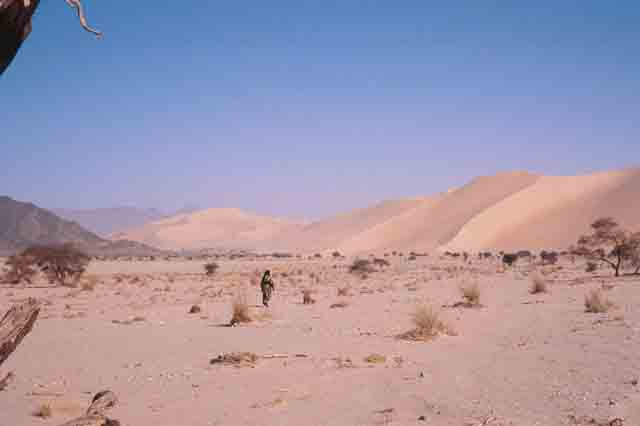
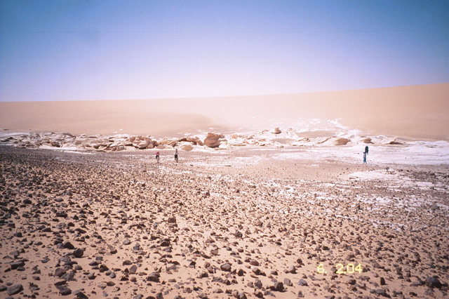
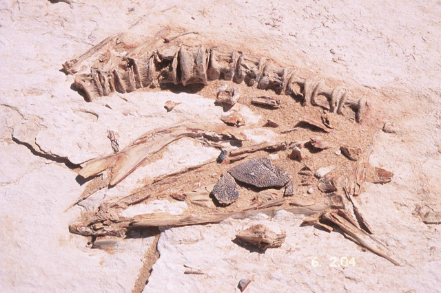
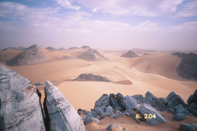
Day  5:  Ti-n-Ouaffadene fossil lake and the Blue Marble Mountains


An exciting first half hours driving to get out of Temet to the sand plain to the east. The dunes are shifting so that the route
is always slightly different.  There are times when there is no drivable route. Once on the plain speed increases up to
60 mph plus.  There are very few vehicle tracks and direction finding is by GPS.  Adrar Bous, the site of the expedition
led by David Hall in 1970 is clearly visible 30 km to the north. A 45km drive brought us to the fossil Lake
of T-I-n Ouaffadene
[N 2o 10 140  :  E 9  10  571] with its little hill to the west clearly visible on the otherwise flat horizon from 30 km away. 
The dried up lake is about 500m in diameter and has number of calcareous deposits of varying thickness within it.
There are numerous pieces of skeleton in the deposits and the sand bed of the lake including fish skeletons. At the margins
of the lake are calcified ferns. Without walking with extreme care it is hard to avoid some damage.  There is much pottery
around the lake shore. We also found the recent carcass of a mallard drake  and a little way from it the skull of an addax,
now extinct.

  click on photo to enlarge


An ancient lake bed, the white
being diatomite.

Part of the skeleton of
a fish.


From T-in-Ouaffadene the Blue marble mountains are some 100 km due south

[ N19  36  09  :  E 9  11  25 ].  On the way we stopped frequently to find and examine grinding stones, pestles, pottery, arrow
 heads, tools and other artefacts, many of which can be easily seen on the flat desert surface. The best of the grinding stones
 and mortars we buried, to avoid theft or destruction by driving over them and took the GPS position. If there is ever a
Museum in Agadez they can be recovered. The huge amount of evidence of human occupation and the clear view of that
there had been a land of shallow lakes and grassland was thought provoking!  The Blue mountains are not named on the
Massif de l’Air map. They are perhaps better described as a group of bare rock outcrops emerging out of the sand dunes.
The marble really is blue, and rather like the skin of a mackerel. They are stunningly beautiful as is the camp site on a large
ledge facing south across the open desert. None better. It would be worth planning one's journey so as to be able to spend
a full day or two exploring the area including high ground to the south east.

  
 click on photo to enlarge


Day6: Adrar Chiriet


Between The Blue Mountains and Adrar Chiriet lie some 20km of shifting dunes. We took a route out of the normal going
east for 10 km then south for 10km. South east for 15km, south for 15 km and then turning south west across the north side
of Adrar Chiriet.  The weather was humid and overcast so we did not get a proper sense of Chiriet towering 3,000 feet
above the desert floor.  We were rewarded with an even greater number of Neolithic finds. We buried 10 grinding stones
and found a perfect green flint knife 2 1/2 inches long and a small stone axe head.  We drove round the west side of
Chiriet and along the south to camp in a corrie at the base in windy hazy conditions.   In briefing  Tim Best before the trip
I had asked that we have as much music  as possible.  At Chiriet it was the 24 carat variety.  We were joined for the night
by Atoa.  Atoa is a nomad and traditional Tuareg singer and story – teller and poet. His dress, black, not indigo, was the
most traditional and conservative we saw and  perfectly arranged, especially his Tagelmoust, which rose high on his head,
holding a curved leather pouch with amulets within the folds. His bearing and demeanour were the epitome of dignity and
courtesy. He dined with us and when eating put a blanket over his head and passed the food under it before passing it
under his veil.

 
 click on photo to enlarge


Atoa, the traditional Tuareg,
The great story teller, poet, and singer


After supper Atoa recited and then sang; in a dialect using old words that Akly said he found difficult to translate into
modern idiom. The story telling was even more enjoyable than the songs. There was rythym, cadence, pace, emphasis
and change in volume.  You knew you were listening to a saga, a fable, or a love poem. Akly provided an outline and it
seemed easy to follow the detail without knowing a single word of Tamasheq.

Two Examples.

A man goes to a woman’s house at night.

She says she is married and her husband is away.

Her husband is like a lion with a sword.

The man says he is strong as an elephant and has the speed of a gazelle.

In the morning

The woman's skirt is untidily tied.


A man goes to hunt truth.

First he has to bury lies in a big hole and build a house on it

He then seeks truth and finds it.

He compares it with camels, fine grass and a beautiful woman.

He describes the woman in such terms of beauty that the Mouflon comes down from the mountain to see the woman and gets killed by the dogs.


[Hunting Mouflon is the ultimate chase for Touareg. It stays in the rockiest parts, is extremely wary and can easily out run
any dog.]


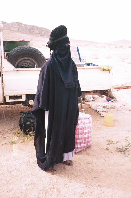
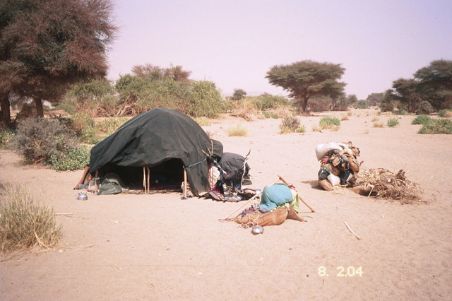
Day 7.  Atoa’s Camp and Illekane.


We drove west from the camp site to the  Tchou-m- Adegdeg  well where Akly keeps a fuel reserve and filled up. We also
filled up every water container from the manually operated 100 ft deep well so as to be able to leave as much as possible
with Atoa at his camp, some 20km further on in the central of the three wide, shallow wadis leading into the  east side of
Adfrar Tamgak.


  click on photo to enlarge


Atoa’s camp was a tarpaulin spread over branches with cooking utensils,
teapot and camel saddle outside.


 Atoa's wife and two children were tending goats sitting under a blanket over sticks. This was similar to all the nomad
herding camps we saw. Water is a major problem and its shortage results in much kidney disease. Atoa was trying to
find water by digging a well but had found nothing at 20feet. Akly showed where there was a rock fault and therefore
greater chance of finding water. We spent an hour , doing sums in the sand working out the cost of a trial well [Euros 350
for crowbar spade bucket, rope. Wheel and labour] and of a permanent well [ Euros 6,000 of which half would be transport] 
at the end of the trip we  gave Akly the money for a trial well .

Camp , after some interesting dune driving, the only time  we bogged down, and a stop at soapstone outcrops, was at
Illekane was in a sheltered hole in high dunes which stretched east as far as one could see. Our findings at the camp
site were a perfect orange flint arrow head and a circular stone bead.


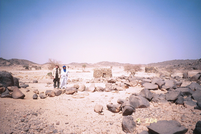
Day 8.  Barth’s Camp at TinTellust.


A day of driving on sandy tracks south west up the Zagado valley which drains the Air to the north east. We stopped at
the first store, a reed hut, near I-n-Guezou selling dates, salt, in bowl shaped blocks, honey, in goatskin bottles for the
caravan trade, basic grains and clothes. We bought traditional trousers made by an itinerant  tailor working a foot treadle
Singer in the back room.

Knowing  we were approaching Tintellust [now Tchintoulous], where F Rodd had identified Heinrich Barth’s first permanent
camp in the Air; August to December 1850, we made enquiries of all we passed, showing the photocopy of Rodd’s
photograph. After several conversations we were becoming despondent about identifying the place. Then we met a man
who did not know of Barth, but recognized the photograph spot and directed us straight to it. It is not at Tchintoulous.
The village has clearly moved, probably with the water supply some kilometers east.along the road.  We were amazed,
and excited. Although all that remains of the hut that Rodd photographed in 1920 is a faint, but clear, ring of palm fronds
showing the outline of the base of the hut, nothing else has changed. Every rock and stone hut is in the same position
and is was easy to see exactly where Rodd had stood on a slightly  elevated flat rock to take the picture.  We spent
several hours exploring the site, which has clearly been abandoned for some time and found only a spear head and
two lines of piles of stones 3 to 5 feet high, which we could not explain three hundred metres west of the camp over
a small ridge. We took the gps  position of the site and agreed not to publish it.

  
click on photo to enlarge


The exact position that Rodd took a photograph in 1920


Akly  told us that there is a story that Barth buried something of value near the camp and if the site becomes known it will
be turned over by treasure hunters and besieged by tourists and the ever attendant trinket sellers.

 [serious travelers should contact jdrl@btinternet.com for the exact location].

We visited Assara, an abandoned village at which Rodd stayed and again identified the precise spot he took
his Photograph. A stone, approx a foot cube, centre right foreground, has not moved in84 years despite flash floods.


Day 9:  Timia


A  relatively short days drive over increasingly rough tracks across volcanic wasteland. We stopped at Assode, the old
capital of the Air. There are the rubble remains of perhaps a 1000 houses of this town, abandoned for reasons not fully

understood in the 1700’s. The mosque, built around 925 AD is just recognizable. Rather a depressing place. Our

destination was Timia where Agadez expeditions has established a good permanent camp site in a garden on the

north side of this major oasis. Although the desert is so dry that you may wash in the sand it was good to be able to

have  an overall wash with abundant water. For those resistant to cold water or foolhardy enough there is a serious

bathing pool 5 km south of Timia; beyond fort Massu, hero of Dien Bien Phu , formed by a volcanic block between

two granite outcrops. Wimps can buy jewelry the while.  The Timia gardens are extensive and produce onions, lettuce,

cabbage, carrots, potatoes, tomatoes, peppers, oranges, lemons, grapefruit, dates, etc. Irrigation is largely by camel

or donkey operated wells and the system is built and maintained by hand. The Village of Timia is unusually clean,

reflecting the Tuareg dominance.


Day 10:  Abarakane and Auderas


A very rough mornings  drive leaving the main road  just east of Kreb Kreb and turning south west towards mt. Bilet and

thence south to Aouderas. This was a change from the planned route, via Elemeki on the main road. Both Barth and Rodd

appear to have used the route and we wanted to check more of Rodd’s photographs from ‘People of the Veil’. Aouderas

is reputed to have the best dancers in the Air Mts.  Agadez expeditions has lunched at Aouderas but had not camped

there for the night.

Before Kreb Kreb we stopped at Abarakane [not marked on the Massif de L’Air map] to visit a silversmith. This provided

the opportunity we had been hoping for to trade the kilo [approx £5 per ounce] of silver grains, sterling 92.5% silver, we

had brought with us for product and labour . We purchased some crosses and earings and left an order for more crosses,

earings and pendants including the human figures on the rock engravings at Iwellen. This last is an initiative by Akly and

Celine Joulia to develop new designs, and thereby a differentiation from the competition. The Joulias arranged for the

shipment of our order, which was high in both quality and quantity  and was better value for money than all but a few 

jewellery purchases elsewhere. It was clear that the smith himself was glad to get hold of good quality silver. Economic

tourism at its most enjoyable.

Some 10km north of Auderas, due west of Mt. Todgha, the track passes a mosque, on the left, made of a low wall of

stones and in excellent condition mentioned in Barths account of his journey from Tintellust to Agadez.

We were unable to identify the sites of Rodd’s photographs in Auderas, but were able to identify  plateau where his

camp had been by climbing the fortress like hill to the south of the eastern end of the village and under whose southern

slope we camped.

The ladies in the party visited the village with Celine and were invited to a tea party, which enabled them to take some

of the best portraits of the trip. Akly and I had an interesting discussion on local government, democracy and elections

with the Chief of Auderas. Election is for life or incapacity, but he may be removed if he makes mistakes. His patch

includes 700 people and 150 ‘houses’.

Akly  had sent Mohammed ahead to announce our arrival and a request that there should be a dance, with a prize

provided by us for the best dancer.

After dark the whole village turned out. The format was as at Iferouane, but there were only torches for light until we

rigged up one 12 volt light on one of the land cruisers. The music was provided by the women clapping, ululating and

by a drum made from a large metal bowl full of water with an up turned wooden bowl floating in it. The drumstick was a

blue flip flop on edge. Asilay, our guitarist was in great demand after the dance. As at Iferouane we were made most

welcome with front row seats. The only drawback being covered in the cloud of dust thrown up by the dancers and

making good photographs hard to come by.


Day 11. Return to Agadez.


A mornings drive back to Agadez and a welcome shower at the Joulias hotel, followed by an afternoon shopping.

The hotel provided a guide for the market.


The final day was spent driving back to Niamey, resting at the Grand Hotel and catching the night flight to Paris.  It

pays to leave Agadez  early in time to check in bags at the airport before going to the Hotel. Akly rejected the

vehicles sent from Niamey, as un-roadworthy, and kindly drove us himself.


Conclusion.


A fascinating trip to one of the poorest parts of one of the poorest countries; with an unusual breadth and balance

of geography, geology, history and modernity, art and artifacts and with a friendly welcome to us from all we met.  

Akly and Celine Joulia  are  superb hosts in every way.


David Lyon

28/06/2004


Appendix 1:  Sources of Information


APPENDIX 1 TO D LYON  REPORT ON VISIT TO AIR MOUNTAINS AND TENERE DESERT   1 TO 14 FEB 2004


SOURCES OF INFORMATION


FR RODD:        THE PEOPLE OF THE VEIL

The most useful source on the Tuareg of the Air.   Available second hand approx £80.

I have a copy. Also copies of Rodd’s RGS articles.


DN  HALL:       BRITISH EXPEDITION TO THE AIR MOUNTAINS 1969/70

Essentially about ADRAR BOUS.

Report Ref 164 RGS Map Room.  Admin and Tech Report Ref 283 RGS Map Room

I have a copy


J  GODWIN:     SAHARA’77, NIGER 1977

Archaeological study of pre Islamic Tombs.  Report Ref 1544 RGS Map Room


DR HEINRICH BARTH : INCLUDING ACCOUNTS OF TRIPOLI THE SAHARA  ETC

Pub London 1890. 2 vols.  RGS Library Control No 302394

Original Edition available reasonably easily via internet for £500 upwards.

I have a copy


PHOTOGRAPHS  RGS PICTURE LIBRARY

PR/036905

PR/036904

PR/036903

PR/036902

All relate to Barths camp at Tin Tellust  [ Now known as Tchintoulous]  Village has moved and houses and site of Barths camp
are known as TADENEK.   Site is N 18 34 449  E 8 50 353  DO NOT PUBLICISE THIS LOCATION

D Lyon has photographs/slides that precisely match Rodd  PhotoG568 ‘ Ruins of Barth’s camp’

Also of precise match of  Rodd photograph of  Assara


 MAPS

SOUTH CENTRAL SAHARA: 1. AIR AND DAMERGU FROMSURVEYS IN 1927 BY F RODD

1:1,000,000

PUB RGS IN GJ LXX111 1929

RGS  Control  No 549980


MASSIF DE L’AIR 1:500,000 Carte Touristique

IGN 1991


AGADEZ  1: 1.000,000

IGN


REPUBLIQUE DU NIGER

1:200,000

IGN 1959-76

RGS Control No 549949

                                                                                                            JDRL 28/06/2004

 TO RETURN TO NEWS AND VIEWS CLICK HERE